Urban/Mixed Use
- Riverwalk San Diego, CA
- 13th & Market San Diego, CA
- Broadway 655 San Diego, CA
- Broadstone Little Italy San Diego, CA
- Broadway Pier San Diego, CA
- Downtown Experience San Diego, CA
- LGBT/North Park Senior Housing San Diego, CA
- Manchester Pacific Gateway San Diego, CA
- Mercado del Barrio San Diego, CA
- N Embarcadero Visionary Plan San Diego, CA
- Smart Corner San Diego, CA
Suburban
Institutional
- Children's Hospital San Diego, CA
- Desert Heights School Phoenix, AZ
- Estrella Community College Phoenix, AZ
- Kroc Community Center San Diego, CA
- Rio Salado College Phoenix, AZ
- Ronald McDonald House San Diego, CA
- Sanford Consortium for Regenerative Medicine La Jolla, CA
- SDSU Mission Valley + Snapdragon Stadium San Diego, CA
Commercial/Retail
Hospitality/Entertainment
- Del Mar Resort Del Mar, CA
- Arizona Cardinals Stadium Glendale, AZ
- Coors Amphitheater Chula Vista, CA
- Manchester Grand Hyatt San Diego, CA
- Lane Field San Diego, CA
- Omni Hotel San Diego, CA
- Petco Park San Diego, CA
- Peoria Sports Complex Peoria, AZ
- Rancho Valencia Resort Rancho Santa Fe, CA
- Convention Center Expansion San Diego, CA
- Seaport Village San Diego, CA
Public Works/Agencies
- Bird Rock Coastal Traffic Flow Improvements La Jolla, CA
- County of San Diego Residential Guidelines County of San Diego, CA
- National City Bayfront Marina District National City, CA
- National City General Plan Update National City, CA
- NCTD As-Needed Civil Engineering County of San Diego, CA
- NCTD As-Needed Survey County of San Diego, CA
Utilities

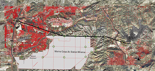
San Vicente Pipeline
County of San Diego, CA
PDC provided surveying, aerial mapping, and right-of-way engineering services for this project. The project was 12-mile 120” diameter bored tunnel with a 108” dia pipeline. The project included a hydroelectric generating station, surge facility, pump station, and two portals, four vertical shafts, and access roads.
Services:
• Research & Title reports
• 1st order GPS control network and ROS
• 920 AC aerial topographic mapping
• Aerial ground control surveys
• Landnet retracement surveys
• Right-of-way/appraisal maps
• Right-of-way monumentation
• Right-of-way record of survey
• GIS data conversion
Phone Site
Copyright Project Design Consultants © 2017

